The Dallas Redistricting Commission is moving forward with two maps to redraw district boundaries.
Commissioners have been meeting since January to evaluate dozens of submissions from residents, following the recent U.S. Census. Data revealed that the population of District 11 was only about 800 off from the ideal number, 93,170. And the population of District 13 was about 2,000 less than the ideal.
The commissioners settled on maps 17 and 41 and began tweaking them. Map 17 was submitted by commissioners Randall Bryant, Bob Stimson and Roy Lopez, and map 41 was submitted by East Dallas residents Melanie Vanlandingham and Darren Dattalo.
The commission could decide on a final map to recommend to the mayor and City Council as early as May 9, and then the council has 45 days to alter and approve a map; otherwise, the version the commission recommended would be adopted. The new map will be in effect by the next City Council election in May 2023.
Maps 17 and 41 both have the populations of District 11 and District 13 above the ideal number.
But there are some differences.
Map 17:
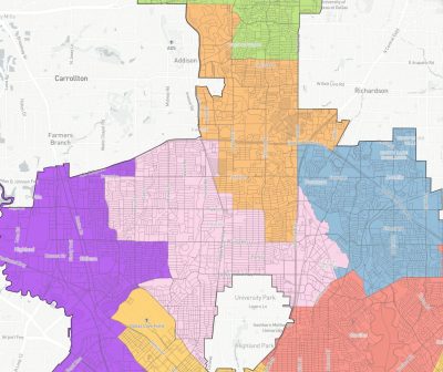
Map 17.
District 13 acquires The Village.
District 11 gains a section from District 13 bounded by Forest Lane, Northaven Road, Preston Road and the Dallas North Tollway. It also gains the eastern part of Melshire Estates, from Nuestra Drive to Preston Road.
It also gains from District 12 a triangular-shaped area east of Preston Road and north of Keller Springs Road.
Map 41:
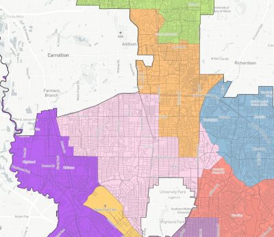
Map 41.
District 13 loses Vickery Meadow, its eastern boundary pushed to Fair Oaks Avenue.
District 11 loses its neighborhoods on the eastern side of Central Expressway north of LBJ, and it loses the small section above Arapaho Road from Hillcrest to Meandering Way. It gains from District 12 almost the same triangular-shaped area near Keller Springs Road and Preston Road.
Compare these to the current maps of District 11 and District 13.