
The Dallas Redistricting Commission tweaked two maps at its May 2 meeting and is ready to hear the public’s feedback.
Maps 17 and 41 were the plans the commissioners agreed to move forward with.
Commissioner Domingo Garcia modified map 17 and came up with this new version. Commissioner Norma Minnis amended map 41 and came up with this new version. These were both adopted by the full commission after discussion.
Residents are invited to share input on the revised maps May 7 at 3:30 p.m. Register to speak at the public hearing here by 10 a.m. tomorrow.
Commissioners are expected to select their final map May 9 and submit their final proposal to the mayor May 16.
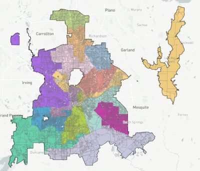
Revised map 17.
Here are some of the key changes in the new map 17 in relation to District 11 and District 13:
- District 11’s western boarder south of LBJ is Preston Road; it lost part of the Melshire Estates neighborhood to District 13.
- District 11 extends north of Arapaho Road in some places east of Meadowcreek Drive. But it lost some area north of Keller Springs Road.
- District 13 spans to Skillman Street.
- District 13 lost to District 2 an area between Greenway Parks and Love Field Airport between W. Lovers Lane and W. Mockingbird Lane.
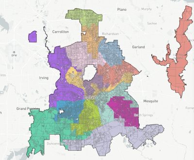
Revised map 41.
Here are some of the key changes in the new map 41 in relation to District 11 and District 13:
- District 11’s northern boundary stops at Keller Springs Road. But it gained area north of Arapaho Road between Meadowcreek Drive and N. Coit Road.
- District 13 gained Vickery Meadow, which was included in District 9 in the first draft of map 41.
- District 13 lost some area to District 2 and District 6 along its western boundary.
Review the earlier versions of the maps here.